عنوان: 58900 (From 58900 To 58999) COUNTY ROAD T, ARAPAHOE, CO 80802-9601, USA
ما هو 80802-9601؟ إنه 80802-9601هو 58900 (From 58900 To 58999) COUNTY ROAD T, ARAPAHOE, CO, USA 5 أضاف4 الرمز البريدي. معلومات التفاصيل علي نحو التالي.
80802-9601 معلومات اساسية

-
الرمز البريدي 5 زائد 4:
80802-9601 -
الرمز البريدي 5:
80802 -
بالإضافة إلى 4?96014-digits that are used to identify a geographic segment within the 5-digit delivery area, such as a city block or a group of apartments or an individual high-volume receiver of mail, or any other unit that could use an extra identifier to aid in efficient mail sorting and delivery. This code is the low end of the range of +4 Codes that pertain to this ZIP Code. ZIP+4 Codes associated with nondelivery areas are composed of valid ZIP sector numbers and "ND" for the ZIP segment number, for example 12345-12ND. Non-deliverable areas are areas to which the USPS does not deliver mail, such as vacant lots and land that borders railroad tracks. Mailers should not match an address identified as a nondelivery area. If you absolutely must have numeric characters in the Plus4Code column, you may treat "ND" values as "00" (zero zero).:
-
بلد:
U.S. - الولايات المتحدة -
حالة:
CO - كولورادو -
مقاطعة:
CountyFIPS: 08017 - Cheyenne County -
مدينة:
ARAPAHOE -
شارع?COUNTY ROAD TThe official name of a street as assigned by a local governing authority. The Street Name column contains only the street name and does not include directionals (EAST, WEST, etc.) or suffixes (ST, DR, BLVD, etc.). This element may also contain literals, such as PO BOX, GENERAL DELIVERY, USS, PSC, or UNIT. Numeric street names that have numeric components that are four characters (or less) in length at are justified such that the low-order digit of the number is positioned in the fourth position of the street name column. This shift is made so that the numeric street names appear in numeric sequence.:
-
نوع السجل?S: شارعAn alphabetic value that identifies the type of data in the record. Record type codes include the following: G = General delivery H = Highrise F = Firm S = Street P = PO box R = Rural route/highway contract:
عنوان

- الرقم المنخفض من العنوان الرئيسي ?
A house, rural route, highway contract box, or post office box number; the numeric or alphanumeric component of an address preceding the street name; the low-end address in a range of addresses. Often referred to as house number.: 58900
- الرقم العالي من العنوان الرئيسي?
A house, rural route, contract box, or Post Office box number. The numeric or alphanumeric component of an address preceding the street name. The high-end address in a range of addresses. Often referred to as house number.: 58999
- رمز فردي من العنوان الرئيسي/رمز زوجي?
Code that identifies the side or sides of a street for which a given address range is applicable. For street, highrise, firm and multi-carrier records, B = Both sides of a street, E = Even side of a street (even-numbered addresses in the range); O = Odd side of a street (odd-numbered addresses in the range). For general delivery, post office box, and rural route/highway contract records, this code will always be "B" (both).: Both of Odd and Even
- ابتدائي نطاق: 58900, 58901, 58902, 58903, 58904, 58905, 58906, 58907, 58908, 58909, 58910, 58911, 58912, 58913, 58914, 58915, 58916, 58917, 58918, 58919, 58920, 58921, 58922, 58923, 58924, 58925, 58926, 58927, 58928, 58929, 58930, 58931, 58932, 58933, 58934, 58935, 58936, 58937, 58938, 58939, 58940, 58941, 58942, 58943, 58944, 58945, 58946, 58947, 58948, 58949, 58950, 58951, 58952, 58953, 58954, 58955, 58956, 58957, 58958, 58959, 58960, 58961, 58962, 58963, 58964, 58965, 58966, 58967, 58968, 58969, 58970, 58971, 58972, 58973, 58974, 58975, 58976, 58977, 58978, 58979, 58980, 58981, 58982, 58983, 58984, 58985, 58986, 58987, 58988, 58989, 58990, 58991, 58992, 58993, 58994, 58995, 58996, 58997, 58998, 58999.
الرجاء النقر فوق "المزيد من أمثلة العنوان" لعرض القائمة بأكملها.
58900 COUNTY ROAD T, ARAPAHOE, CO 80802-9601
58901 COUNTY ROAD T, ARAPAHOE, CO 80802-9601
58902 COUNTY ROAD T, ARAPAHOE, CO 80802-9601
58903 COUNTY ROAD T, ARAPAHOE, CO 80802-9601
58904 COUNTY ROAD T, ARAPAHOE, CO 80802-9601
58905 COUNTY ROAD T, ARAPAHOE, CO 80802-9601
58906 COUNTY ROAD T, ARAPAHOE, CO 80802-9601
58907 COUNTY ROAD T, ARAPAHOE, CO 80802-9601
58908 COUNTY ROAD T, ARAPAHOE, CO 80802-9601
58909 COUNTY ROAD T, ARAPAHOE, CO 80802-9601
58910 COUNTY ROAD T, ARAPAHOE, CO 80802-9601
58911 COUNTY ROAD T, ARAPAHOE, CO 80802-9601
58912 COUNTY ROAD T, ARAPAHOE, CO 80802-9601
58913 COUNTY ROAD T, ARAPAHOE, CO 80802-9601
58914 COUNTY ROAD T, ARAPAHOE, CO 80802-9601
58915 COUNTY ROAD T, ARAPAHOE, CO 80802-9601
58916 COUNTY ROAD T, ARAPAHOE, CO 80802-9601
58917 COUNTY ROAD T, ARAPAHOE, CO 80802-9601
58918 COUNTY ROAD T, ARAPAHOE, CO 80802-9601
58919 COUNTY ROAD T, ARAPAHOE, CO 80802-9601
58920 COUNTY ROAD T, ARAPAHOE, CO 80802-9601
58921 COUNTY ROAD T, ARAPAHOE, CO 80802-9601
58922 COUNTY ROAD T, ARAPAHOE, CO 80802-9601
58923 COUNTY ROAD T, ARAPAHOE, CO 80802-9601
58924 COUNTY ROAD T, ARAPAHOE, CO 80802-9601
58925 COUNTY ROAD T, ARAPAHOE, CO 80802-9601
58926 COUNTY ROAD T, ARAPAHOE, CO 80802-9601
58927 COUNTY ROAD T, ARAPAHOE, CO 80802-9601
58928 COUNTY ROAD T, ARAPAHOE, CO 80802-9601
58929 COUNTY ROAD T, ARAPAHOE, CO 80802-9601
58930 COUNTY ROAD T, ARAPAHOE, CO 80802-9601
58931 COUNTY ROAD T, ARAPAHOE, CO 80802-9601
58932 COUNTY ROAD T, ARAPAHOE, CO 80802-9601
58933 COUNTY ROAD T, ARAPAHOE, CO 80802-9601
58934 COUNTY ROAD T, ARAPAHOE, CO 80802-9601
58935 COUNTY ROAD T, ARAPAHOE, CO 80802-9601
58936 COUNTY ROAD T, ARAPAHOE, CO 80802-9601
58937 COUNTY ROAD T, ARAPAHOE, CO 80802-9601
58938 COUNTY ROAD T, ARAPAHOE, CO 80802-9601
58939 COUNTY ROAD T, ARAPAHOE, CO 80802-9601
58940 COUNTY ROAD T, ARAPAHOE, CO 80802-9601
58941 COUNTY ROAD T, ARAPAHOE, CO 80802-9601
58942 COUNTY ROAD T, ARAPAHOE, CO 80802-9601
58943 COUNTY ROAD T, ARAPAHOE, CO 80802-9601
58944 COUNTY ROAD T, ARAPAHOE, CO 80802-9601
58945 COUNTY ROAD T, ARAPAHOE, CO 80802-9601
58946 COUNTY ROAD T, ARAPAHOE, CO 80802-9601
58947 COUNTY ROAD T, ARAPAHOE, CO 80802-9601
58948 COUNTY ROAD T, ARAPAHOE, CO 80802-9601
58949 COUNTY ROAD T, ARAPAHOE, CO 80802-9601
58950 COUNTY ROAD T, ARAPAHOE, CO 80802-9601
58951 COUNTY ROAD T, ARAPAHOE, CO 80802-9601
58952 COUNTY ROAD T, ARAPAHOE, CO 80802-9601
58953 COUNTY ROAD T, ARAPAHOE, CO 80802-9601
58954 COUNTY ROAD T, ARAPAHOE, CO 80802-9601
58955 COUNTY ROAD T, ARAPAHOE, CO 80802-9601
58956 COUNTY ROAD T, ARAPAHOE, CO 80802-9601
58957 COUNTY ROAD T, ARAPAHOE, CO 80802-9601
58958 COUNTY ROAD T, ARAPAHOE, CO 80802-9601
58959 COUNTY ROAD T, ARAPAHOE, CO 80802-9601
58960 COUNTY ROAD T, ARAPAHOE, CO 80802-9601
58961 COUNTY ROAD T, ARAPAHOE, CO 80802-9601
58962 COUNTY ROAD T, ARAPAHOE, CO 80802-9601
58963 COUNTY ROAD T, ARAPAHOE, CO 80802-9601
58964 COUNTY ROAD T, ARAPAHOE, CO 80802-9601
58965 COUNTY ROAD T, ARAPAHOE, CO 80802-9601
58966 COUNTY ROAD T, ARAPAHOE, CO 80802-9601
58967 COUNTY ROAD T, ARAPAHOE, CO 80802-9601
58968 COUNTY ROAD T, ARAPAHOE, CO 80802-9601
58969 COUNTY ROAD T, ARAPAHOE, CO 80802-9601
58970 COUNTY ROAD T, ARAPAHOE, CO 80802-9601
58971 COUNTY ROAD T, ARAPAHOE, CO 80802-9601
58972 COUNTY ROAD T, ARAPAHOE, CO 80802-9601
58973 COUNTY ROAD T, ARAPAHOE, CO 80802-9601
58974 COUNTY ROAD T, ARAPAHOE, CO 80802-9601
58975 COUNTY ROAD T, ARAPAHOE, CO 80802-9601
58976 COUNTY ROAD T, ARAPAHOE, CO 80802-9601
58977 COUNTY ROAD T, ARAPAHOE, CO 80802-9601
58978 COUNTY ROAD T, ARAPAHOE, CO 80802-9601
58979 COUNTY ROAD T, ARAPAHOE, CO 80802-9601
58980 COUNTY ROAD T, ARAPAHOE, CO 80802-9601
58981 COUNTY ROAD T, ARAPAHOE, CO 80802-9601
58982 COUNTY ROAD T, ARAPAHOE, CO 80802-9601
58983 COUNTY ROAD T, ARAPAHOE, CO 80802-9601
58984 COUNTY ROAD T, ARAPAHOE, CO 80802-9601
58985 COUNTY ROAD T, ARAPAHOE, CO 80802-9601
58986 COUNTY ROAD T, ARAPAHOE, CO 80802-9601
58987 COUNTY ROAD T, ARAPAHOE, CO 80802-9601
58988 COUNTY ROAD T, ARAPAHOE, CO 80802-9601
58989 COUNTY ROAD T, ARAPAHOE, CO 80802-9601
58990 COUNTY ROAD T, ARAPAHOE, CO 80802-9601
58991 COUNTY ROAD T, ARAPAHOE, CO 80802-9601
58992 COUNTY ROAD T, ARAPAHOE, CO 80802-9601
58993 COUNTY ROAD T, ARAPAHOE, CO 80802-9601
58994 COUNTY ROAD T, ARAPAHOE, CO 80802-9601
58995 COUNTY ROAD T, ARAPAHOE, CO 80802-9601
58996 COUNTY ROAD T, ARAPAHOE, CO 80802-9601
58997 COUNTY ROAD T, ARAPAHOE, CO 80802-9601
58998 COUNTY ROAD T, ARAPAHOE, CO 80802-9601
58999 COUNTY ROAD T, ARAPAHOE, CO 80802-9601
عنوان مثال
ARAPAHOE CO 80802-9601
UNITED STATES OF AMERICA
80802-9601 مثال المغلف

-
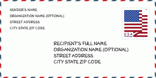
هذا مثال على مغلف الولايات المتحدة. املأ معلومات المرسل في أعلى اليسار ومعلومات المستلم في أسفل اليمين. المعلومات الضرورية هي الاسم الكامل للمرسل / المستلم وعنوان الشارع والمدينة والولاية والرمز البريدي. تم تقديم معلومات عنوان المستلم كمرجع لك. بشكل عام ، إذا لم تكن متأكدًا من الرمز البريدي الكامل المكون من 9 أرقام ، فيمكنك فقط ملء الرمز البريدي المكون من 5 أرقام لتجنب فقد الحزمة.
80802-9601 المعنى الأساسي
-
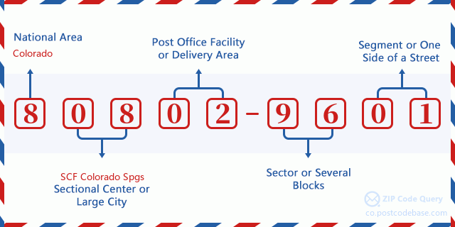
ما الذي يرمز إليه كل رقم في الرمز البريدي 80802-9601؟ يتكون الرمز البريدي + 4 من جزأين ، يمكن تحديد موقع أول خمسة أرقام في مكتب البريد ، ويمكن للأرقام الأربعة الأخيرة تحديد مقطع جغرافي داخل منطقة التسليم المكونة من خمسة أرقام. تحدد الأرقام المكونة من 6 إلى 7 أرقام قطاعًا أو عدة كتل ، بينما تحدد الأرقام المكونة من 8 إلى 9 أرقام مقطعًا أو جانبًا واحدًا من الشارع.

- ·طرق النقل ID?
A 4-digit code assigned to a mail delivery or collection route within a 5-digit ZIP Code. The first character of this identification is alphabetical, and the last three are numeric: Bnnn = PO box Hnnn = Highway contract Rnnn = Rural route Cnnn = City delivery Gnnn = General delivery: H002 (عقد الطريق السريع)
- ·أضاف البريد علي قطاع منخفضة?
The ZIP Add-On Low Sector and the ZIP Add-On Low Segment together form the ZIP Add-On Low Number. The ZIP Add-On Low Number is the last four positions of a ZIP+4 code; the low-end ZIP add-on in a range of codes; the add-on of the first ZIP+4 code in a consecutive series of ZIP+4 codes assigned to the delivery address. For example, most delivery addresses are assigned a single ZIP+4 code. However, large companies may be given a range of ZIP+4 codes that can be used to route mail to specific departments. A range of ZIP+4 codes can also be assigned to a corresponding range of post office boxes, and each box is mapped, one-to-one, with a ZIP+4 code in the range. A single post office box can also be assigned a range of ZIP+4 codes.: 96
- ·أضاف البريد علي جزء منخفضة?
The ZIP Add-On Low Sector and the ZIP Add-On Low Segment together form the ZIP Add-On Low Number. The ZIP Add-On Low Number is the last four positions of a ZIP+4 code; the low-end ZIP add-on in a range of codes; the add-on of the first ZIP+4 code in a consecutive series of ZIP+4 codes assigned to the delivery address. For example, most delivery addresses are assigned a single ZIP+4 code. However, large companies may be given a range of ZIP+4 codes that can be used to route mail to specific departments. A range of ZIP+4 codes can also be assigned to a corresponding range of post office boxes, and each box is mapped, one-to-one, with a ZIP+4 code in the range. A single post office box can also be assigned a range of ZIP+4 codes.: 01
- ·أضاف البريد علي قطاع عالية?
The ZIP Add-On High Sector and the ZIP Add-On High Segment together form the ZIP Add-On High Number, which is the high-end ZIP add-on in a range of codes; the add-on of the last ZIP+4 code in a consecutive series of ZIP+4 codes assigned to the delivery address. Most delivery addresses are assigned a single ZIP+4 code; however, large companies may be given a range of ZIP+4 codes that can be used to route mail to specific departments. A range of ZIP+4 codes can also be assigned to a corresponding range of post office boxes, and each box is mapped, one-to-one, with a ZIP+4 code in the range. A single post office box can also be assigned a range of ZIP+4 codes. (See also ZIP Add-On Code.): 96
- ·أضاف البريد علي جزء عالية?
The ZIP Add-On High Sector and the ZIP Add-On High Segment together form the ZIP Add-On High Number, which is the high-end ZIP add-on in a range of codes; the add-on of the last ZIP+4 code in a consecutive series of ZIP+4 codes assigned to the delivery address. Most delivery addresses are assigned a single ZIP+4 code; however, large companies may be given a range of ZIP+4 codes that can be used to route mail to specific departments. A range of ZIP+4 codes can also be assigned to a corresponding range of post office boxes, and each box is mapped, one-to-one, with a ZIP+4 code in the range. A single post office box can also be assigned a range of ZIP+4 codes. (See also ZIP Add-On Code.): 01
- ·الرمز البريدي ملحق: 9601
- ·نطاق?
The range of +4 codes. Summing the +4 Code and the +4 Range will give you the high end of the range of +4 Codes that pertain to this ZIP Code.: 0
- ·رمز البديل الأساسي?
Code that specifies whether a record is a base (preferred) or alternate record. Base records (represented as "B") can represent a range of addresses or an individual address, such as a firm record, while alternate records (represented as "A") are individual delivery points. Government deliveries will only be listed on alternate records with the appropriate government building indicator (federal, state, or city) set.: قاعدة
- ·الأرقام المالية?
A code assigned to Postal Service facilities (primarily post offices) to collect cost and statistical data and compile revenue and expense data. The state number comprises the first two positions of the finance number.: 070270
- ·رقم منطقة الكونغرس?
A standard value identifying a geographic area within the United States served by a member of the US House of Representatives or Senate. If Army/Air Force (APO) or fleet post office (FPO), this column will be blank. If there is only one member of Congress within a state, the code will be "AL" (at large).: 04
- ·رمز المدينة المفضلة الأخير?
An index to the City State file that provides the preferred last-line name for this address range.: Z11032
خريطة الانترنت

هذا هو عنوان 58900 COUNTY ROAD T ARAPAHOE مطابقة الخريطة الإلكترونية عبر الإنترنت يمكنك استخدام زر في الخريطة للتحرك وتكبير. معلومات الخريطة هي للإشارة فقط.
عنوان: 58900 (From 58900 To 58999) COUNTY ROAD T, ARAPAHOE, CO 80802-9601, USA
التعليق


إضافة تعليق جديد