Adresse: 20000 (From 20000 To 22999) COUNTY ROAD 50, ARAPAHOE, CO 80802-9627, USA
Was ist 80802-9627? 80802-9627 ist ein PLZ-Code 5 Plus 4 Zahl von 20000 (From 20000 To 22999) COUNTY ROAD 50, ARAPAHOE, CO, USA. Nachfolgend finden Sie Detailinformationen.
80802-9627 Grundinformation

-
Postleitzahl 5 Plus 4:
80802-9627 -
Postleitzahl 5:
80802 -
Plus 4?96274-digits that are used to identify a geographic segment within the 5-digit delivery area, such as a city block or a group of apartments or an individual high-volume receiver of mail, or any other unit that could use an extra identifier to aid in efficient mail sorting and delivery. This code is the low end of the range of +4 Codes that pertain to this ZIP Code. ZIP+4 Codes associated with nondelivery areas are composed of valid ZIP sector numbers and "ND" for the ZIP segment number, for example 12345-12ND. Non-deliverable areas are areas to which the USPS does not deliver mail, such as vacant lots and land that borders railroad tracks. Mailers should not match an address identified as a nondelivery area. If you absolutely must have numeric characters in the Plus4Code column, you may treat "ND" values as "00" (zero zero).:
-
Land:
U.S. - Vereinigte Staaten -
Bundesland:
CO - Colorado -
Grafschaft:
CountyFIPS: 08017 - Cheyenne County -
Stadt:
ARAPAHOE -
Straße?COUNTY ROAD 50The official name of a street as assigned by a local governing authority. The Street Name column contains only the street name and does not include directionals (EAST, WEST, etc.) or suffixes (ST, DR, BLVD, etc.). This element may also contain literals, such as PO BOX, GENERAL DELIVERY, USS, PSC, or UNIT. Numeric street names that have numeric components that are four characters (or less) in length at are justified such that the low-order digit of the number is positioned in the fourth position of the street name column. This shift is made so that the numeric street names appear in numeric sequence.:
-
Rekordtyp?S: StraßeAn alphabetic value that identifies the type of data in the record. Record type codes include the following: G = General delivery H = Highrise F = Firm S = Street P = PO box R = Rural route/highway contract:
Adresse

- Primäre Adresse Niedrige Zahl?
A house, rural route, highway contract box, or post office box number; the numeric or alphanumeric component of an address preceding the street name; the low-end address in a range of addresses. Often referred to as house number.: 20000
- Primäre Adresse Hohe Zahl?
A house, rural route, contract box, or Post Office box number. The numeric or alphanumeric component of an address preceding the street name. The high-end address in a range of addresses. Often referred to as house number.: 22999
- Primäre Adresse Gerader/Ungerader Code?
Code that identifies the side or sides of a street for which a given address range is applicable. For street, highrise, firm and multi-carrier records, B = Both sides of a street, E = Even side of a street (even-numbered addresses in the range); O = Odd side of a street (odd-numbered addresses in the range). For general delivery, post office box, and rural route/highway contract records, this code will always be "B" (both).: Both of Odd and Even
- Primär Reichweite: 20000, 20001, 20002, 20003, 20004, 20005, 20006, 20007, 20008, 20009, 20010, 20011, 20012, 20013, 20014, 20015, 20016, 20017, 20018, 20019, 20020, 20021, 20022, 20023, 20024, 20025, 20026, 20027, 20028, 20029, 20030, 20031, 20032, 20033, 20034, 20035, 20036, 20037, 20038, 20039, 20040, 20041, 20042, 20043, 20044, 20045, 20046, 20047, 20048, 20049, 20050, 20051, 20052, 20053, 20054, 20055, 20056, 20057, 20058, 20059, 20060, 20061, 20062, 20063, 20064, 20065, 20066, 20067, 20068, 20069, 20070, 20071, 20072, 20073, 20074, 20075, 20076, 20077, 20078, 20079, 20080, 20081, 20082, 20083, 20084, 20085, 20086, 20087, 20088, 20089, 20090, 20091, 20092, 20093, 20094, 20095, 20096, 20097, 20098, 20099, 20100, 20101, 20102, 20103, 20104, 20105, 20106, 20107, 20108, 20109, 20110, 20111, 20112, 20113, 20114, 20115, 20116, 20117, 20118, 20119, 20120, 20121, 20122, 20123, 20124, 20125, 20126, 20127, 20128, 20129, 20130, 20131, 20132, 20133, 20134, 20135, 20136, 20137, 20138, 20139, 20140, 20141, 20142, 20143, 20144, 20145, 20146, 20147, 20148, 20149, 20150, 20151, 20152, 20153, 20154, 20155, 20156, 20157, 20158, 20159, 20160, 20161, 20162, 20163, 20164, 20165, 20166, 20167, 20168, 20169, 20170, 20171, 20172, 20173, 20174, 20175, 20176, 20177, 20178, 20179, 20180, 20181, 20182, 20183, 20184, 20185, 20186, 20187, 20188, 20189, 20190, 20191, 20192, 20193, 20194, 20195, 20196, 20197, 20198, 20199, 20200.
Bitte klicken Sie auf die "Weitere Adressbeispiele", um die gesamte Liste anzuzeigen.
20000 COUNTY ROAD 50, ARAPAHOE, CO 80802-9627
20001 COUNTY ROAD 50, ARAPAHOE, CO 80802-9627
20002 COUNTY ROAD 50, ARAPAHOE, CO 80802-9627
20003 COUNTY ROAD 50, ARAPAHOE, CO 80802-9627
20004 COUNTY ROAD 50, ARAPAHOE, CO 80802-9627
20005 COUNTY ROAD 50, ARAPAHOE, CO 80802-9627
20006 COUNTY ROAD 50, ARAPAHOE, CO 80802-9627
20007 COUNTY ROAD 50, ARAPAHOE, CO 80802-9627
20008 COUNTY ROAD 50, ARAPAHOE, CO 80802-9627
20009 COUNTY ROAD 50, ARAPAHOE, CO 80802-9627
20010 COUNTY ROAD 50, ARAPAHOE, CO 80802-9627
20011 COUNTY ROAD 50, ARAPAHOE, CO 80802-9627
20012 COUNTY ROAD 50, ARAPAHOE, CO 80802-9627
20013 COUNTY ROAD 50, ARAPAHOE, CO 80802-9627
20014 COUNTY ROAD 50, ARAPAHOE, CO 80802-9627
20015 COUNTY ROAD 50, ARAPAHOE, CO 80802-9627
20016 COUNTY ROAD 50, ARAPAHOE, CO 80802-9627
20017 COUNTY ROAD 50, ARAPAHOE, CO 80802-9627
20018 COUNTY ROAD 50, ARAPAHOE, CO 80802-9627
20019 COUNTY ROAD 50, ARAPAHOE, CO 80802-9627
20020 COUNTY ROAD 50, ARAPAHOE, CO 80802-9627
20021 COUNTY ROAD 50, ARAPAHOE, CO 80802-9627
20022 COUNTY ROAD 50, ARAPAHOE, CO 80802-9627
20023 COUNTY ROAD 50, ARAPAHOE, CO 80802-9627
20024 COUNTY ROAD 50, ARAPAHOE, CO 80802-9627
20025 COUNTY ROAD 50, ARAPAHOE, CO 80802-9627
20026 COUNTY ROAD 50, ARAPAHOE, CO 80802-9627
20027 COUNTY ROAD 50, ARAPAHOE, CO 80802-9627
20028 COUNTY ROAD 50, ARAPAHOE, CO 80802-9627
20029 COUNTY ROAD 50, ARAPAHOE, CO 80802-9627
20030 COUNTY ROAD 50, ARAPAHOE, CO 80802-9627
20031 COUNTY ROAD 50, ARAPAHOE, CO 80802-9627
20032 COUNTY ROAD 50, ARAPAHOE, CO 80802-9627
20033 COUNTY ROAD 50, ARAPAHOE, CO 80802-9627
20034 COUNTY ROAD 50, ARAPAHOE, CO 80802-9627
20035 COUNTY ROAD 50, ARAPAHOE, CO 80802-9627
20036 COUNTY ROAD 50, ARAPAHOE, CO 80802-9627
20037 COUNTY ROAD 50, ARAPAHOE, CO 80802-9627
20038 COUNTY ROAD 50, ARAPAHOE, CO 80802-9627
20039 COUNTY ROAD 50, ARAPAHOE, CO 80802-9627
20040 COUNTY ROAD 50, ARAPAHOE, CO 80802-9627
20041 COUNTY ROAD 50, ARAPAHOE, CO 80802-9627
20042 COUNTY ROAD 50, ARAPAHOE, CO 80802-9627
20043 COUNTY ROAD 50, ARAPAHOE, CO 80802-9627
20044 COUNTY ROAD 50, ARAPAHOE, CO 80802-9627
20045 COUNTY ROAD 50, ARAPAHOE, CO 80802-9627
20046 COUNTY ROAD 50, ARAPAHOE, CO 80802-9627
20047 COUNTY ROAD 50, ARAPAHOE, CO 80802-9627
20048 COUNTY ROAD 50, ARAPAHOE, CO 80802-9627
20049 COUNTY ROAD 50, ARAPAHOE, CO 80802-9627
20050 COUNTY ROAD 50, ARAPAHOE, CO 80802-9627
20051 COUNTY ROAD 50, ARAPAHOE, CO 80802-9627
20052 COUNTY ROAD 50, ARAPAHOE, CO 80802-9627
20053 COUNTY ROAD 50, ARAPAHOE, CO 80802-9627
20054 COUNTY ROAD 50, ARAPAHOE, CO 80802-9627
20055 COUNTY ROAD 50, ARAPAHOE, CO 80802-9627
20056 COUNTY ROAD 50, ARAPAHOE, CO 80802-9627
20057 COUNTY ROAD 50, ARAPAHOE, CO 80802-9627
20058 COUNTY ROAD 50, ARAPAHOE, CO 80802-9627
20059 COUNTY ROAD 50, ARAPAHOE, CO 80802-9627
20060 COUNTY ROAD 50, ARAPAHOE, CO 80802-9627
20061 COUNTY ROAD 50, ARAPAHOE, CO 80802-9627
20062 COUNTY ROAD 50, ARAPAHOE, CO 80802-9627
20063 COUNTY ROAD 50, ARAPAHOE, CO 80802-9627
20064 COUNTY ROAD 50, ARAPAHOE, CO 80802-9627
20065 COUNTY ROAD 50, ARAPAHOE, CO 80802-9627
20066 COUNTY ROAD 50, ARAPAHOE, CO 80802-9627
20067 COUNTY ROAD 50, ARAPAHOE, CO 80802-9627
20068 COUNTY ROAD 50, ARAPAHOE, CO 80802-9627
20069 COUNTY ROAD 50, ARAPAHOE, CO 80802-9627
20070 COUNTY ROAD 50, ARAPAHOE, CO 80802-9627
20071 COUNTY ROAD 50, ARAPAHOE, CO 80802-9627
20072 COUNTY ROAD 50, ARAPAHOE, CO 80802-9627
20073 COUNTY ROAD 50, ARAPAHOE, CO 80802-9627
20074 COUNTY ROAD 50, ARAPAHOE, CO 80802-9627
20075 COUNTY ROAD 50, ARAPAHOE, CO 80802-9627
20076 COUNTY ROAD 50, ARAPAHOE, CO 80802-9627
20077 COUNTY ROAD 50, ARAPAHOE, CO 80802-9627
20078 COUNTY ROAD 50, ARAPAHOE, CO 80802-9627
20079 COUNTY ROAD 50, ARAPAHOE, CO 80802-9627
20080 COUNTY ROAD 50, ARAPAHOE, CO 80802-9627
20081 COUNTY ROAD 50, ARAPAHOE, CO 80802-9627
20082 COUNTY ROAD 50, ARAPAHOE, CO 80802-9627
20083 COUNTY ROAD 50, ARAPAHOE, CO 80802-9627
20084 COUNTY ROAD 50, ARAPAHOE, CO 80802-9627
20085 COUNTY ROAD 50, ARAPAHOE, CO 80802-9627
20086 COUNTY ROAD 50, ARAPAHOE, CO 80802-9627
20087 COUNTY ROAD 50, ARAPAHOE, CO 80802-9627
20088 COUNTY ROAD 50, ARAPAHOE, CO 80802-9627
20089 COUNTY ROAD 50, ARAPAHOE, CO 80802-9627
20090 COUNTY ROAD 50, ARAPAHOE, CO 80802-9627
20091 COUNTY ROAD 50, ARAPAHOE, CO 80802-9627
20092 COUNTY ROAD 50, ARAPAHOE, CO 80802-9627
20093 COUNTY ROAD 50, ARAPAHOE, CO 80802-9627
20094 COUNTY ROAD 50, ARAPAHOE, CO 80802-9627
20095 COUNTY ROAD 50, ARAPAHOE, CO 80802-9627
20096 COUNTY ROAD 50, ARAPAHOE, CO 80802-9627
20097 COUNTY ROAD 50, ARAPAHOE, CO 80802-9627
20098 COUNTY ROAD 50, ARAPAHOE, CO 80802-9627
20099 COUNTY ROAD 50, ARAPAHOE, CO 80802-9627
20100 COUNTY ROAD 50, ARAPAHOE, CO 80802-9627
20101 COUNTY ROAD 50, ARAPAHOE, CO 80802-9627
20102 COUNTY ROAD 50, ARAPAHOE, CO 80802-9627
20103 COUNTY ROAD 50, ARAPAHOE, CO 80802-9627
20104 COUNTY ROAD 50, ARAPAHOE, CO 80802-9627
20105 COUNTY ROAD 50, ARAPAHOE, CO 80802-9627
20106 COUNTY ROAD 50, ARAPAHOE, CO 80802-9627
20107 COUNTY ROAD 50, ARAPAHOE, CO 80802-9627
20108 COUNTY ROAD 50, ARAPAHOE, CO 80802-9627
20109 COUNTY ROAD 50, ARAPAHOE, CO 80802-9627
20110 COUNTY ROAD 50, ARAPAHOE, CO 80802-9627
20111 COUNTY ROAD 50, ARAPAHOE, CO 80802-9627
20112 COUNTY ROAD 50, ARAPAHOE, CO 80802-9627
20113 COUNTY ROAD 50, ARAPAHOE, CO 80802-9627
20114 COUNTY ROAD 50, ARAPAHOE, CO 80802-9627
20115 COUNTY ROAD 50, ARAPAHOE, CO 80802-9627
20116 COUNTY ROAD 50, ARAPAHOE, CO 80802-9627
20117 COUNTY ROAD 50, ARAPAHOE, CO 80802-9627
20118 COUNTY ROAD 50, ARAPAHOE, CO 80802-9627
20119 COUNTY ROAD 50, ARAPAHOE, CO 80802-9627
20120 COUNTY ROAD 50, ARAPAHOE, CO 80802-9627
20121 COUNTY ROAD 50, ARAPAHOE, CO 80802-9627
20122 COUNTY ROAD 50, ARAPAHOE, CO 80802-9627
20123 COUNTY ROAD 50, ARAPAHOE, CO 80802-9627
20124 COUNTY ROAD 50, ARAPAHOE, CO 80802-9627
20125 COUNTY ROAD 50, ARAPAHOE, CO 80802-9627
20126 COUNTY ROAD 50, ARAPAHOE, CO 80802-9627
20127 COUNTY ROAD 50, ARAPAHOE, CO 80802-9627
20128 COUNTY ROAD 50, ARAPAHOE, CO 80802-9627
20129 COUNTY ROAD 50, ARAPAHOE, CO 80802-9627
20130 COUNTY ROAD 50, ARAPAHOE, CO 80802-9627
20131 COUNTY ROAD 50, ARAPAHOE, CO 80802-9627
20132 COUNTY ROAD 50, ARAPAHOE, CO 80802-9627
20133 COUNTY ROAD 50, ARAPAHOE, CO 80802-9627
20134 COUNTY ROAD 50, ARAPAHOE, CO 80802-9627
20135 COUNTY ROAD 50, ARAPAHOE, CO 80802-9627
20136 COUNTY ROAD 50, ARAPAHOE, CO 80802-9627
20137 COUNTY ROAD 50, ARAPAHOE, CO 80802-9627
20138 COUNTY ROAD 50, ARAPAHOE, CO 80802-9627
20139 COUNTY ROAD 50, ARAPAHOE, CO 80802-9627
20140 COUNTY ROAD 50, ARAPAHOE, CO 80802-9627
20141 COUNTY ROAD 50, ARAPAHOE, CO 80802-9627
20142 COUNTY ROAD 50, ARAPAHOE, CO 80802-9627
20143 COUNTY ROAD 50, ARAPAHOE, CO 80802-9627
20144 COUNTY ROAD 50, ARAPAHOE, CO 80802-9627
20145 COUNTY ROAD 50, ARAPAHOE, CO 80802-9627
20146 COUNTY ROAD 50, ARAPAHOE, CO 80802-9627
20147 COUNTY ROAD 50, ARAPAHOE, CO 80802-9627
20148 COUNTY ROAD 50, ARAPAHOE, CO 80802-9627
20149 COUNTY ROAD 50, ARAPAHOE, CO 80802-9627
20150 COUNTY ROAD 50, ARAPAHOE, CO 80802-9627
20151 COUNTY ROAD 50, ARAPAHOE, CO 80802-9627
20152 COUNTY ROAD 50, ARAPAHOE, CO 80802-9627
20153 COUNTY ROAD 50, ARAPAHOE, CO 80802-9627
20154 COUNTY ROAD 50, ARAPAHOE, CO 80802-9627
20155 COUNTY ROAD 50, ARAPAHOE, CO 80802-9627
20156 COUNTY ROAD 50, ARAPAHOE, CO 80802-9627
20157 COUNTY ROAD 50, ARAPAHOE, CO 80802-9627
20158 COUNTY ROAD 50, ARAPAHOE, CO 80802-9627
20159 COUNTY ROAD 50, ARAPAHOE, CO 80802-9627
20160 COUNTY ROAD 50, ARAPAHOE, CO 80802-9627
20161 COUNTY ROAD 50, ARAPAHOE, CO 80802-9627
20162 COUNTY ROAD 50, ARAPAHOE, CO 80802-9627
20163 COUNTY ROAD 50, ARAPAHOE, CO 80802-9627
20164 COUNTY ROAD 50, ARAPAHOE, CO 80802-9627
20165 COUNTY ROAD 50, ARAPAHOE, CO 80802-9627
20166 COUNTY ROAD 50, ARAPAHOE, CO 80802-9627
20167 COUNTY ROAD 50, ARAPAHOE, CO 80802-9627
20168 COUNTY ROAD 50, ARAPAHOE, CO 80802-9627
20169 COUNTY ROAD 50, ARAPAHOE, CO 80802-9627
20170 COUNTY ROAD 50, ARAPAHOE, CO 80802-9627
20171 COUNTY ROAD 50, ARAPAHOE, CO 80802-9627
20172 COUNTY ROAD 50, ARAPAHOE, CO 80802-9627
20173 COUNTY ROAD 50, ARAPAHOE, CO 80802-9627
20174 COUNTY ROAD 50, ARAPAHOE, CO 80802-9627
20175 COUNTY ROAD 50, ARAPAHOE, CO 80802-9627
20176 COUNTY ROAD 50, ARAPAHOE, CO 80802-9627
20177 COUNTY ROAD 50, ARAPAHOE, CO 80802-9627
20178 COUNTY ROAD 50, ARAPAHOE, CO 80802-9627
20179 COUNTY ROAD 50, ARAPAHOE, CO 80802-9627
20180 COUNTY ROAD 50, ARAPAHOE, CO 80802-9627
20181 COUNTY ROAD 50, ARAPAHOE, CO 80802-9627
20182 COUNTY ROAD 50, ARAPAHOE, CO 80802-9627
20183 COUNTY ROAD 50, ARAPAHOE, CO 80802-9627
20184 COUNTY ROAD 50, ARAPAHOE, CO 80802-9627
20185 COUNTY ROAD 50, ARAPAHOE, CO 80802-9627
20186 COUNTY ROAD 50, ARAPAHOE, CO 80802-9627
20187 COUNTY ROAD 50, ARAPAHOE, CO 80802-9627
20188 COUNTY ROAD 50, ARAPAHOE, CO 80802-9627
20189 COUNTY ROAD 50, ARAPAHOE, CO 80802-9627
20190 COUNTY ROAD 50, ARAPAHOE, CO 80802-9627
20191 COUNTY ROAD 50, ARAPAHOE, CO 80802-9627
20192 COUNTY ROAD 50, ARAPAHOE, CO 80802-9627
20193 COUNTY ROAD 50, ARAPAHOE, CO 80802-9627
20194 COUNTY ROAD 50, ARAPAHOE, CO 80802-9627
20195 COUNTY ROAD 50, ARAPAHOE, CO 80802-9627
20196 COUNTY ROAD 50, ARAPAHOE, CO 80802-9627
20197 COUNTY ROAD 50, ARAPAHOE, CO 80802-9627
20198 COUNTY ROAD 50, ARAPAHOE, CO 80802-9627
20199 COUNTY ROAD 50, ARAPAHOE, CO 80802-9627
20200 COUNTY ROAD 50, ARAPAHOE, CO 80802-9627
Adresse Beispiel
ARAPAHOE CO 80802-9627
UNITED STATES OF AMERICA
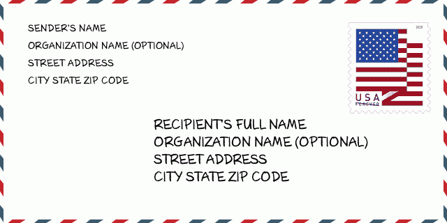
80802-9627 Umschlagbeispiel

-
Dies ist ein Beispiel für einen US-Umschlag. Geben Sie oben links die Informationen des Absenders und unten rechts die Informationen des Empfängers ein. Die erforderlichen Informationen sind der vollständige Name des Absenders/Empfängers, die Anschrift, der Ort, das Bundesland und die Postleitzahl. Die Adressdaten des Empfängers wurden zu Ihrer Information angegeben. Im Allgemeinen gilt: Wenn Sie sich bei der vollständigen 9-stelligen Postleitzahl nicht sicher sind, können Sie nur die 5-stellige Postleitzahl eingeben, um einen Paketverlust zu vermeiden.
80802-9627 Grundlegende Bedeutung
-
Wofür steht jede Ziffer der Postleitzahl 80802-9627? Die Postleitzahl+4 besteht aus zwei Teilen, wobei die ersten fünf Ziffern die Poststelle angeben und die letzten vier Ziffern ein geografisches Segment innerhalb des fünfstelligen Zustellgebiets identifizieren können. Die Ziffern 6-7 bezeichnen einen Sektor oder mehrere Blöcke und die Ziffern 8-9 bezeichnen ein Segment oder eine Straßenseite.
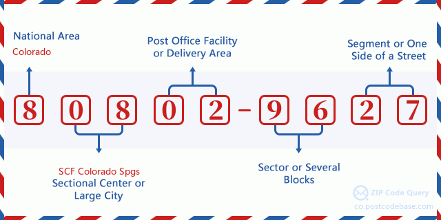

- ·Transportwege-ID?
A 4-digit code assigned to a mail delivery or collection route within a 5-digit ZIP Code. The first character of this identification is alphabetical, and the last three are numeric: Bnnn = PO box Hnnn = Highway contract Rnnn = Rural route Cnnn = City delivery Gnnn = General delivery: H002 (Autobahnvertrag)
- ·ZIP Plus Niederiger Sektor?
The ZIP Add-On Low Sector and the ZIP Add-On Low Segment together form the ZIP Add-On Low Number. The ZIP Add-On Low Number is the last four positions of a ZIP+4 code; the low-end ZIP add-on in a range of codes; the add-on of the first ZIP+4 code in a consecutive series of ZIP+4 codes assigned to the delivery address. For example, most delivery addresses are assigned a single ZIP+4 code. However, large companies may be given a range of ZIP+4 codes that can be used to route mail to specific departments. A range of ZIP+4 codes can also be assigned to a corresponding range of post office boxes, and each box is mapped, one-to-one, with a ZIP+4 code in the range. A single post office box can also be assigned a range of ZIP+4 codes.: 96
- ·ZIP Plus Niederiges Segment?
The ZIP Add-On Low Sector and the ZIP Add-On Low Segment together form the ZIP Add-On Low Number. The ZIP Add-On Low Number is the last four positions of a ZIP+4 code; the low-end ZIP add-on in a range of codes; the add-on of the first ZIP+4 code in a consecutive series of ZIP+4 codes assigned to the delivery address. For example, most delivery addresses are assigned a single ZIP+4 code. However, large companies may be given a range of ZIP+4 codes that can be used to route mail to specific departments. A range of ZIP+4 codes can also be assigned to a corresponding range of post office boxes, and each box is mapped, one-to-one, with a ZIP+4 code in the range. A single post office box can also be assigned a range of ZIP+4 codes.: 27
- ·ZIP Plus Hoher Sektor?
The ZIP Add-On High Sector and the ZIP Add-On High Segment together form the ZIP Add-On High Number, which is the high-end ZIP add-on in a range of codes; the add-on of the last ZIP+4 code in a consecutive series of ZIP+4 codes assigned to the delivery address. Most delivery addresses are assigned a single ZIP+4 code; however, large companies may be given a range of ZIP+4 codes that can be used to route mail to specific departments. A range of ZIP+4 codes can also be assigned to a corresponding range of post office boxes, and each box is mapped, one-to-one, with a ZIP+4 code in the range. A single post office box can also be assigned a range of ZIP+4 codes. (See also ZIP Add-On Code.): 96
- ·ZIP Plus Hohes Segment?
The ZIP Add-On High Sector and the ZIP Add-On High Segment together form the ZIP Add-On High Number, which is the high-end ZIP add-on in a range of codes; the add-on of the last ZIP+4 code in a consecutive series of ZIP+4 codes assigned to the delivery address. Most delivery addresses are assigned a single ZIP+4 code; however, large companies may be given a range of ZIP+4 codes that can be used to route mail to specific departments. A range of ZIP+4 codes can also be assigned to a corresponding range of post office boxes, and each box is mapped, one-to-one, with a ZIP+4 code in the range. A single post office box can also be assigned a range of ZIP+4 codes. (See also ZIP Add-On Code.): 27
- ·Postleitzahl Hinzufügen: 9627
- ·Reichweite?
The range of +4 codes. Summing the +4 Code and the +4 Range will give you the high end of the range of +4 Codes that pertain to this ZIP Code.: 0
- ·Grundlegender Alternativer Code?
Code that specifies whether a record is a base (preferred) or alternate record. Base records (represented as "B") can represent a range of addresses or an individual address, such as a firm record, while alternate records (represented as "A") are individual delivery points. Government deliveries will only be listed on alternate records with the appropriate government building indicator (federal, state, or city) set.: Basis
- ·Finanzkennzahl?
A code assigned to Postal Service facilities (primarily post offices) to collect cost and statistical data and compile revenue and expense data. The state number comprises the first two positions of the finance number.: 070270
- ·Bundeswahlkreisnummer?
A standard value identifying a geographic area within the United States served by a member of the US House of Representatives or Senate. If Army/Air Force (APO) or fleet post office (FPO), this column will be blank. If there is only one member of Congress within a state, the code will be "AL" (at large).: 04
- ·Bevorzugte letzte Zeile Stadtstaatschlüssel?
An index to the City State file that provides the preferred last-line name for this address range.: Z11032
Online Map

Das ist Online-Karte der adresse 20000 COUNTY ROAD 50 ARAPAHOE. Sie können Knopf verwenden, um zu bewegen und vergrößern/ verkleinern. Die Karteninformation dient nur als Referenz.
Adresse: 20000 (From 20000 To 22999) COUNTY ROAD 50, ARAPAHOE, CO 80802-9627, USA
Kommentar


Neuen Kommentar schreiben