نشانی: 12500 (From 12500 To 12581) MAGNOLIA WAY, THORNTON, CO 80602-4201, USA
؟80602-4201 چیست 80602-4201 یک کد فشرده 5 به همراه 4 عدد از 12500 (From 12500 To 12581) MAGNOLIA WAY, THORNTON, CO, USA است. اطلاعات بیشتر در زیر آمده است.
80602-4201 اطلاعات اولیه

-
کد پستی 5 به علاوه 4:
80602-4201 -
کد پستی 5:
80602 -
به علاوه 4?42014-digits that are used to identify a geographic segment within the 5-digit delivery area, such as a city block or a group of apartments or an individual high-volume receiver of mail, or any other unit that could use an extra identifier to aid in efficient mail sorting and delivery. This code is the low end of the range of +4 Codes that pertain to this ZIP Code. ZIP+4 Codes associated with nondelivery areas are composed of valid ZIP sector numbers and "ND" for the ZIP segment number, for example 12345-12ND. Non-deliverable areas are areas to which the USPS does not deliver mail, such as vacant lots and land that borders railroad tracks. Mailers should not match an address identified as a nondelivery area. If you absolutely must have numeric characters in the Plus4Code column, you may treat "ND" values as "00" (zero zero).:
-
کشور:
U.S. - ایالات متحده -
دولت:
CO - کلرادو -
شهرستان:
CountyFIPS: 08001 - Adams County -
شهر:
THORNTON -
خیابان?MAGNOLIA WAYThe official name of a street as assigned by a local governing authority. The Street Name column contains only the street name and does not include directionals (EAST, WEST, etc.) or suffixes (ST, DR, BLVD, etc.). This element may also contain literals, such as PO BOX, GENERAL DELIVERY, USS, PSC, or UNIT. Numeric street names that have numeric components that are four characters (or less) in length at are justified such that the low-order digit of the number is positioned in the fourth position of the street name column. This shift is made so that the numeric street names appear in numeric sequence.:
-
پسوند خیابان?WAYThe street suffix: For Example: ST = Street RD = Road DR = Drive LN = Lane:
-
نوع ثبت?S: خیابانAn alphabetic value that identifies the type of data in the record. Record type codes include the following: G = General delivery H = Highrise F = Firm S = Street P = PO box R = Rural route/highway contract:
نشانی

- شماره پایین آدرس اولیه?
A house, rural route, highway contract box, or post office box number; the numeric or alphanumeric component of an address preceding the street name; the low-end address in a range of addresses. Often referred to as house number.: 12500
- شماره بالا آدرس اولیه?
A house, rural route, contract box, or Post Office box number. The numeric or alphanumeric component of an address preceding the street name. The high-end address in a range of addresses. Often referred to as house number.: 12581
- کد فرد/ زوج آدرس اولیه?
Code that identifies the side or sides of a street for which a given address range is applicable. For street, highrise, firm and multi-carrier records, B = Both sides of a street, E = Even side of a street (even-numbered addresses in the range); O = Odd side of a street (odd-numbered addresses in the range). For general delivery, post office box, and rural route/highway contract records, this code will always be "B" (both).: Both of Odd and Even
- اولیه محدوده: 12500, 12501, 12502, 12503, 12504, 12505, 12506, 12507, 12508, 12509, 12510, 12511, 12512, 12513, 12514, 12515, 12516, 12517, 12518, 12519, 12520, 12521, 12522, 12523, 12524, 12525, 12526, 12527, 12528, 12529, 12530, 12531, 12532, 12533, 12534, 12535, 12536, 12537, 12538, 12539, 12540, 12541, 12542, 12543, 12544, 12545, 12546, 12547, 12548, 12549, 12550, 12551, 12552, 12553, 12554, 12555, 12556, 12557, 12558, 12559, 12560, 12561, 12562, 12563, 12564, 12565, 12566, 12567, 12568, 12569, 12570, 12571, 12572, 12573, 12574, 12575, 12576, 12577, 12578, 12579, 12580, 12581.
لطفاً برای مشاهده کل لیست ، بر روی "نمونه های آدرس بیشتر" کلیک کنید.
12500 MAGNOLIA WAY, THORNTON, CO 80602-4201
12501 MAGNOLIA WAY, THORNTON, CO 80602-4201
12502 MAGNOLIA WAY, THORNTON, CO 80602-4201
12503 MAGNOLIA WAY, THORNTON, CO 80602-4201
12504 MAGNOLIA WAY, THORNTON, CO 80602-4201
12505 MAGNOLIA WAY, THORNTON, CO 80602-4201
12506 MAGNOLIA WAY, THORNTON, CO 80602-4201
12507 MAGNOLIA WAY, THORNTON, CO 80602-4201
12508 MAGNOLIA WAY, THORNTON, CO 80602-4201
12509 MAGNOLIA WAY, THORNTON, CO 80602-4201
12510 MAGNOLIA WAY, THORNTON, CO 80602-4201
12511 MAGNOLIA WAY, THORNTON, CO 80602-4201
12512 MAGNOLIA WAY, THORNTON, CO 80602-4201
12513 MAGNOLIA WAY, THORNTON, CO 80602-4201
12514 MAGNOLIA WAY, THORNTON, CO 80602-4201
12515 MAGNOLIA WAY, THORNTON, CO 80602-4201
12516 MAGNOLIA WAY, THORNTON, CO 80602-4201
12517 MAGNOLIA WAY, THORNTON, CO 80602-4201
12518 MAGNOLIA WAY, THORNTON, CO 80602-4201
12519 MAGNOLIA WAY, THORNTON, CO 80602-4201
12520 MAGNOLIA WAY, THORNTON, CO 80602-4201
12521 MAGNOLIA WAY, THORNTON, CO 80602-4201
12522 MAGNOLIA WAY, THORNTON, CO 80602-4201
12523 MAGNOLIA WAY, THORNTON, CO 80602-4201
12524 MAGNOLIA WAY, THORNTON, CO 80602-4201
12525 MAGNOLIA WAY, THORNTON, CO 80602-4201
12526 MAGNOLIA WAY, THORNTON, CO 80602-4201
12527 MAGNOLIA WAY, THORNTON, CO 80602-4201
12528 MAGNOLIA WAY, THORNTON, CO 80602-4201
12529 MAGNOLIA WAY, THORNTON, CO 80602-4201
12530 MAGNOLIA WAY, THORNTON, CO 80602-4201
12531 MAGNOLIA WAY, THORNTON, CO 80602-4201
12532 MAGNOLIA WAY, THORNTON, CO 80602-4201
12533 MAGNOLIA WAY, THORNTON, CO 80602-4201
12534 MAGNOLIA WAY, THORNTON, CO 80602-4201
12535 MAGNOLIA WAY, THORNTON, CO 80602-4201
12536 MAGNOLIA WAY, THORNTON, CO 80602-4201
12537 MAGNOLIA WAY, THORNTON, CO 80602-4201
12538 MAGNOLIA WAY, THORNTON, CO 80602-4201
12539 MAGNOLIA WAY, THORNTON, CO 80602-4201
12540 MAGNOLIA WAY, THORNTON, CO 80602-4201
12541 MAGNOLIA WAY, THORNTON, CO 80602-4201
12542 MAGNOLIA WAY, THORNTON, CO 80602-4201
12543 MAGNOLIA WAY, THORNTON, CO 80602-4201
12544 MAGNOLIA WAY, THORNTON, CO 80602-4201
12545 MAGNOLIA WAY, THORNTON, CO 80602-4201
12546 MAGNOLIA WAY, THORNTON, CO 80602-4201
12547 MAGNOLIA WAY, THORNTON, CO 80602-4201
12548 MAGNOLIA WAY, THORNTON, CO 80602-4201
12549 MAGNOLIA WAY, THORNTON, CO 80602-4201
12550 MAGNOLIA WAY, THORNTON, CO 80602-4201
12551 MAGNOLIA WAY, THORNTON, CO 80602-4201
12552 MAGNOLIA WAY, THORNTON, CO 80602-4201
12553 MAGNOLIA WAY, THORNTON, CO 80602-4201
12554 MAGNOLIA WAY, THORNTON, CO 80602-4201
12555 MAGNOLIA WAY, THORNTON, CO 80602-4201
12556 MAGNOLIA WAY, THORNTON, CO 80602-4201
12557 MAGNOLIA WAY, THORNTON, CO 80602-4201
12558 MAGNOLIA WAY, THORNTON, CO 80602-4201
12559 MAGNOLIA WAY, THORNTON, CO 80602-4201
12560 MAGNOLIA WAY, THORNTON, CO 80602-4201
12561 MAGNOLIA WAY, THORNTON, CO 80602-4201
12562 MAGNOLIA WAY, THORNTON, CO 80602-4201
12563 MAGNOLIA WAY, THORNTON, CO 80602-4201
12564 MAGNOLIA WAY, THORNTON, CO 80602-4201
12565 MAGNOLIA WAY, THORNTON, CO 80602-4201
12566 MAGNOLIA WAY, THORNTON, CO 80602-4201
12567 MAGNOLIA WAY, THORNTON, CO 80602-4201
12568 MAGNOLIA WAY, THORNTON, CO 80602-4201
12569 MAGNOLIA WAY, THORNTON, CO 80602-4201
12570 MAGNOLIA WAY, THORNTON, CO 80602-4201
12571 MAGNOLIA WAY, THORNTON, CO 80602-4201
12572 MAGNOLIA WAY, THORNTON, CO 80602-4201
12573 MAGNOLIA WAY, THORNTON, CO 80602-4201
12574 MAGNOLIA WAY, THORNTON, CO 80602-4201
12575 MAGNOLIA WAY, THORNTON, CO 80602-4201
12576 MAGNOLIA WAY, THORNTON, CO 80602-4201
12577 MAGNOLIA WAY, THORNTON, CO 80602-4201
12578 MAGNOLIA WAY, THORNTON, CO 80602-4201
12579 MAGNOLIA WAY, THORNTON, CO 80602-4201
12580 MAGNOLIA WAY, THORNTON, CO 80602-4201
12581 MAGNOLIA WAY, THORNTON, CO 80602-4201
نشانی مثال
THORNTON CO 80602-4201
UNITED STATES OF AMERICA
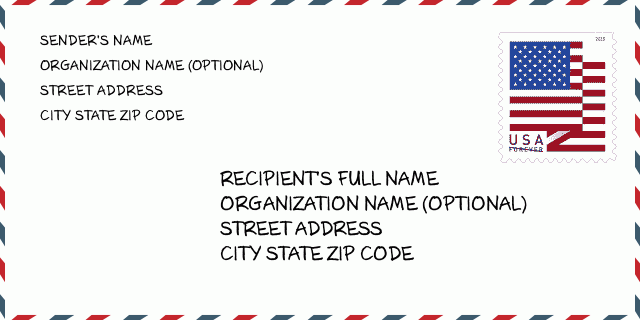
80602-4201 نمونه پاکت

-
این نمونه ای از پاکت نامه ایالات متحده است. اطلاعات فرستنده را در بالا سمت چپ و اطلاعات گیرنده را در پایین سمت راست وارد کنید. اطلاعات لازم نام کامل فرستنده/گیرنده ، آدرس خیابان ، شهر ، ایالت و کد پستی است. اطلاعات آدرس گیرنده برای مرجع شما داده شده است. به طور کلی ، اگر از کد پستی کامل 9 رقمی مطمئن نیستید ، فقط می توانید کد پستی 5 رقمی را پر کنید تا از دست دادن بسته جلوگیری شود.
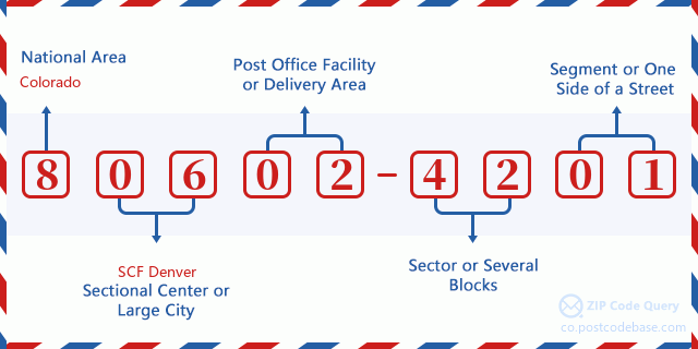
80602-4201 معنای اساسی
-
هر رقم کد پستی 80602-4201 مخفف چیست؟ کد ZIP+4 از دو بخش تشکیل شده است، پنج رقم اول را می توان در اداره پست قرار داد، و چهار رقم آخر می تواند یک بخش جغرافیایی را در منطقه تحویل پنج رقمی مشخص کند. 6-7 رقم بخش یا چند بلوک را مشخص می کند و رقم 8-9 نشان دهنده بخش یا یک طرف خیابان است.

- ·شناسایی مسیر حامل?
A 4-digit code assigned to a mail delivery or collection route within a 5-digit ZIP Code. The first character of this identification is alphabetical, and the last three are numeric: Bnnn = PO box Hnnn = Highway contract Rnnn = Rural route Cnnn = City delivery Gnnn = General delivery: R043 (مسیر روستایی)
- ·بخش پایین افزونه فشرده?
The ZIP Add-On Low Sector and the ZIP Add-On Low Segment together form the ZIP Add-On Low Number. The ZIP Add-On Low Number is the last four positions of a ZIP+4 code; the low-end ZIP add-on in a range of codes; the add-on of the first ZIP+4 code in a consecutive series of ZIP+4 codes assigned to the delivery address. For example, most delivery addresses are assigned a single ZIP+4 code. However, large companies may be given a range of ZIP+4 codes that can be used to route mail to specific departments. A range of ZIP+4 codes can also be assigned to a corresponding range of post office boxes, and each box is mapped, one-to-one, with a ZIP+4 code in the range. A single post office box can also be assigned a range of ZIP+4 codes.: 42
- ·بخش پایین افزونه فشرده?
The ZIP Add-On Low Sector and the ZIP Add-On Low Segment together form the ZIP Add-On Low Number. The ZIP Add-On Low Number is the last four positions of a ZIP+4 code; the low-end ZIP add-on in a range of codes; the add-on of the first ZIP+4 code in a consecutive series of ZIP+4 codes assigned to the delivery address. For example, most delivery addresses are assigned a single ZIP+4 code. However, large companies may be given a range of ZIP+4 codes that can be used to route mail to specific departments. A range of ZIP+4 codes can also be assigned to a corresponding range of post office boxes, and each box is mapped, one-to-one, with a ZIP+4 code in the range. A single post office box can also be assigned a range of ZIP+4 codes.: 01
- ·بخش بالا افزونه فشرده?
The ZIP Add-On High Sector and the ZIP Add-On High Segment together form the ZIP Add-On High Number, which is the high-end ZIP add-on in a range of codes; the add-on of the last ZIP+4 code in a consecutive series of ZIP+4 codes assigned to the delivery address. Most delivery addresses are assigned a single ZIP+4 code; however, large companies may be given a range of ZIP+4 codes that can be used to route mail to specific departments. A range of ZIP+4 codes can also be assigned to a corresponding range of post office boxes, and each box is mapped, one-to-one, with a ZIP+4 code in the range. A single post office box can also be assigned a range of ZIP+4 codes. (See also ZIP Add-On Code.): 42
- ·بخش بالا افزونه فشرده?
The ZIP Add-On High Sector and the ZIP Add-On High Segment together form the ZIP Add-On High Number, which is the high-end ZIP add-on in a range of codes; the add-on of the last ZIP+4 code in a consecutive series of ZIP+4 codes assigned to the delivery address. Most delivery addresses are assigned a single ZIP+4 code; however, large companies may be given a range of ZIP+4 codes that can be used to route mail to specific departments. A range of ZIP+4 codes can also be assigned to a corresponding range of post office boxes, and each box is mapped, one-to-one, with a ZIP+4 code in the range. A single post office box can also be assigned a range of ZIP+4 codes. (See also ZIP Add-On Code.): 01
- ·کد پستی افزونه: 4201
- ·محدوده?
The range of +4 codes. Summing the +4 Code and the +4 Range will give you the high end of the range of +4 Codes that pertain to this ZIP Code.: 0
- ·کد متناوب پایه?
Code that specifies whether a record is a base (preferred) or alternate record. Base records (represented as "B") can represent a range of addresses or an individual address, such as a firm record, while alternate records (represented as "A") are individual delivery points. Government deliveries will only be listed on alternate records with the appropriate government building indicator (federal, state, or city) set.: پایه
- ·شماره مالی?
A code assigned to Postal Service facilities (primarily post offices) to collect cost and statistical data and compile revenue and expense data. The state number comprises the first two positions of the finance number.: 071044
- ·شماره ناحیه کنگره?
A standard value identifying a geographic area within the United States served by a member of the US House of Representatives or Senate. If Army/Air Force (APO) or fleet post office (FPO), this column will be blank. If there is only one member of Congress within a state, the code will be "AL" (at large).: 07
- ·کلید دولتی خط نهایی ترجیحی?
An index to the City State file that provides the preferred last-line name for this address range.: Z11941
نقشه آنلاین

این نقشه آنلاین آدرس 12500 MAGNOLIA WAY, THORNTON است. برای حرکت و زوم میتوانید از دکمه استفاده کنید. اطلاعات نقشه تنها برای مرجع است.
نشانی: 12500 (From 12500 To 12581) MAGNOLIA WAY, THORNTON, CO 80602-4201, USA
دیدگاه


