Jesteś tutaj

Adres: 10767 (From 10767 To 10773) W (West) 62ND PL, ARVADA, CO 80004-4824, USA

Co to jest 80004-4824? 80004-4824 to kod pocztowy 5 Plus 4 liczba 10767 (From 10767 To 10773) W (West) 62ND PL, ARVADA, CO, USA. Bliższe informacje poniżej.

80004-4824 Podstawowe informacje

img_Postal
  • Kod Pocztowy 5 Plus 4:

    80004-4824
  • Kod Pocztowy 5:

    80004
  • Plus 4?
    4-digits that are used to identify a geographic segment within the 5-digit delivery area, such as a city block or a group of apartments or an individual high-volume receiver of mail, or any other unit that could use an extra identifier to aid in efficient mail sorting and delivery. This code is the low end of the range of +4 Codes that pertain to this ZIP Code. ZIP+4 Codes associated with nondelivery areas are composed of valid ZIP sector numbers and "ND" for the ZIP segment number, for example 12345-12ND. Non-deliverable areas are areas to which the USPS does not deliver mail, such as vacant lots and land that borders railroad tracks. Mailers should not match an address identified as a nondelivery area. If you absolutely must have numeric characters in the Plus4Code column, you may treat "ND" values as "00" (zero zero).
    :
    4824
  • Kraj:

    U.S. - Stany Zjednoczone
  • Państwo/stan:

    CO - Colorado
  • Hrabstwo:

    CountyFIPS: 08059 - Jefferson County
  • Miasto:

    ARVADA
  • Przedkierunkowy Ulicy:

    W (West)
  • Ulica?
    The official name of a street as assigned by a local governing authority. The Street Name column contains only the street name and does not include directionals (EAST, WEST, etc.) or suffixes (ST, DR, BLVD, etc.). This element may also contain literals, such as PO BOX, GENERAL DELIVERY, USS, PSC, or UNIT. Numeric street names that have numeric components that are four characters (or less) in length at are justified such that the low-order digit of the number is positioned in the fourth position of the street name column. This shift is made so that the numeric street names appear in numeric sequence.
    :
    62ND PL
  • Sufiks Ulicy?
    The street suffix: For Example: ST = Street RD = Road DR = Drive LN = Lane
    :
    PL
  • Rodzaj Danych?
    An alphabetic value that identifies the type of data in the record. Record type codes include the following: G = General delivery H = Highrise F = Firm S = Street P = PO box R = Rural route/highway contract
    :
    S: Ulica

Adres

img_region

80004-4824 odpowiada następującym adresom.

Lista adresówStatus
10701 (From 10701 To 10713) W (West) 62ND PL, ARVADA, CO 80004-4824, USAważny
10727 (From 10727 To 10733) W (West) 62ND PL, ARVADA, CO 80004-4824, USAważny
10747 (From 10747 To 10753) W (West) 62ND PL, ARVADA, CO 80004-4824, USAważny
10717 (From 10717 To 10723) W (West) 62ND PL, ARVADA, CO 80004-4824, USAważny
10737 (From 10737 To 10743) W (West) 62ND PL, ARVADA, CO 80004-4824, USAważny
10767 (From 10767 To 10773) W (West) 62ND PL, ARVADA, CO 80004-4824, USAważny

Kliknij "Więcej przykładów adresów", aby wyświetlić całą listę.

[+]Więcej przykładów adresów

Adres Przykład

img_region
Adres składa się z następujących wierszy:
10767 W (West) 62ND PL
ARVADA CO 80004-4824
UNITED STATES OF AMERICA
lub Możesz sprawdzić przykład koperty poniżej, aby uzyskać więcej informacji.

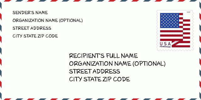
80004-4824 Przykład Koperty

img_envelope
  • To jest przykład koperty amerykańskiej. Wpisz informacje o nadawcy w lewym górnym rogu i informacje o odbiorcy w prawym dolnym rogu. Niezbędne informacje to imię i nazwisko nadawcy/odbiorcy, adres, miasto, województwo i kod pocztowy. Dane adresowe odbiorcy zostały podane w celach informacyjnych. Ogólnie rzecz biorąc, jeśli nie masz pewności co do pełnego 9-cyfrowego kodu pocztowego, możesz wpisać tylko 5-cyfrowy kod pocztowy, aby uniknąć utraty paczki.

    ZIP Code: 80004-4824

80004-4824 Podstawowe znaczenie

img_envelope
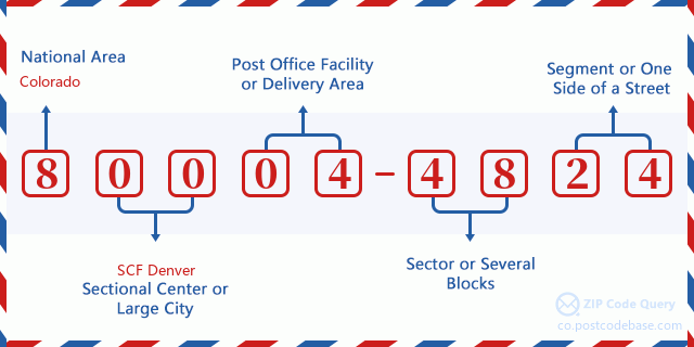
  • Co oznacza każda cyfra kodu pocztowego 80004-4824? Kod pocztowy + 4 składa się z dwóch części, pierwsze pięć cyfr może znajdować się w urzędzie pocztowym, a ostatnie cztery cyfry mogą identyfikować segment geograficzny w pięciocyfrowym obszarze dostawy. Cyfry 6-7 oznaczają sektor lub kilka bloków, a cyfry 8-9 oznaczają odcinek lub jedną stronę ulicy.

    ZIP Code: 80004-4824

Mapa

Mapa

To mapa sieciowa adresu 10767 W (West) 62ND PL, ARVADA. Mapę można przybliżyć. Mapa przeznaczona jest wyłącznie dla celów informacyjnych.

Adres: 10767 (From 10767 To 10773) W (West) 62ND PL, ARVADA, CO 80004-4824, USA

Komentarz

Komentarz

Dodaj komentarz