You are here

Endereço: 10767 (From 10767 To 10773) W (West) 62ND PL, ARVADA, CO 80004-4824, USA

O que é o 80004-4824? 80004-4824 é um número de CEP 5 Plus 4 de 10767 (From 10767 To 10773) W (West) 62ND PL, ARVADA, CO, USA. Abaixo estão as informações detalhadas.

80004-4824 Informação básica

img_Postal
  • CEP 5 mais 4:

    80004-4824
  • CEP 5:

    80004
  • Mais 4?
    4-digits that are used to identify a geographic segment within the 5-digit delivery area, such as a city block or a group of apartments or an individual high-volume receiver of mail, or any other unit that could use an extra identifier to aid in efficient mail sorting and delivery. This code is the low end of the range of +4 Codes that pertain to this ZIP Code. ZIP+4 Codes associated with nondelivery areas are composed of valid ZIP sector numbers and "ND" for the ZIP segment number, for example 12345-12ND. Non-deliverable areas are areas to which the USPS does not deliver mail, such as vacant lots and land that borders railroad tracks. Mailers should not match an address identified as a nondelivery area. If you absolutely must have numeric characters in the Plus4Code column, you may treat "ND" values as "00" (zero zero).
    :
    4824
  • País:

    U.S. - United States
  • Estado:

    CO - Colorado
  • Condado:

    CountyFIPS: 08059 - Jefferson County
  • Cidade:

    ARVADA
  • Street Predirectional:

    W (West)
  • Rua?
    The official name of a street as assigned by a local governing authority. The Street Name column contains only the street name and does not include directionals (EAST, WEST, etc.) or suffixes (ST, DR, BLVD, etc.). This element may also contain literals, such as PO BOX, GENERAL DELIVERY, USS, PSC, or UNIT. Numeric street names that have numeric components that are four characters (or less) in length at are justified such that the low-order digit of the number is positioned in the fourth position of the street name column. This shift is made so that the numeric street names appear in numeric sequence.
    :
    62ND PL
  • Sufixo de rua?
    The street suffix: For Example: ST = Street RD = Road DR = Drive LN = Lane
    :
    PL
  • Tipo de Registro?
    An alphabetic value that identifies the type of data in the record. Record type codes include the following: G = General delivery H = Highrise F = Firm S = Street P = PO box R = Rural route/highway contract
    :
    S: Rua

Endereço

img_region

80004-4824 corresponde aos seguintes endereços.

Lista de endereçosStatus
10701 (From 10701 To 10713) W (West) 62ND PL, ARVADA, CO 80004-4824, USAválido
10727 (From 10727 To 10733) W (West) 62ND PL, ARVADA, CO 80004-4824, USAválido
10747 (From 10747 To 10753) W (West) 62ND PL, ARVADA, CO 80004-4824, USAválido
10717 (From 10717 To 10723) W (West) 62ND PL, ARVADA, CO 80004-4824, USAválido
10737 (From 10737 To 10743) W (West) 62ND PL, ARVADA, CO 80004-4824, USAválido
10767 (From 10767 To 10773) W (West) 62ND PL, ARVADA, CO 80004-4824, USAválido

Clique no "Mais exemplos de endereços" para ver a lista completa.

[+]Mais exemplos de endereços

Endereço Exemplo

img_region
O endereço é composto pelas seguintes linhas:
10767 W (West) 62ND PL
ARVADA CO 80004-4824
UNITED STATES OF AMERICA
ou Você pode conferir o exemplo de envelope abaixo para obter mais informações.

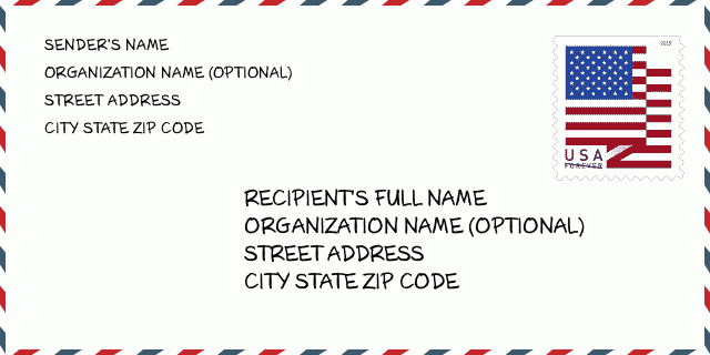
80004-4824 Exemplo de envelope

img_envelope
  • Este é um exemplo de envelope americano. Preencha as informações do remetente no canto superior esquerdo e as informações do destinatário no canto inferior direito. As informações necessárias são o nome completo do remetente / destinatário, endereço, cidade, estado e código postal. As informações do endereço do destinatário foram fornecidas para sua referência. Geralmente, se você não tiver certeza do código postal de 9 dígitos completo, só poderá preencher o código postal de 5 dígitos para evitar a perda do pacote.

    ZIP Code: 80004-4824

80004-4824 Significado Básico

img_envelope
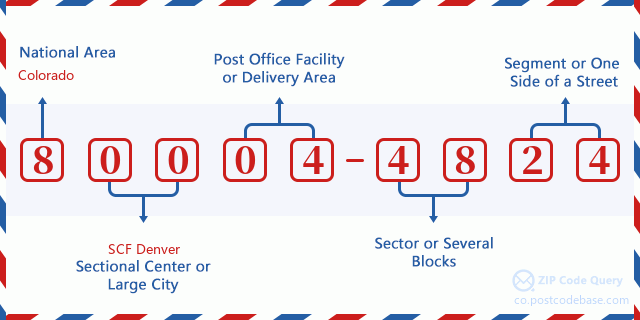
  • O que cada dígito do CEP 80004-4824 representa? O código ZIP + 4 consiste em duas partes, os primeiros cinco dígitos podem ser localizados na agência dos correios e os últimos quatro dígitos podem identificar um segmento geográfico dentro da área de entrega de cinco dígitos. Os 6 a 7 dígitos designam o setor ou vários blocos, e os 8 a 9 dígitos designam o segmento ou um lado de uma rua.

    ZIP Code: 80004-4824

Mapa Online

Mapa Online

Este é o mapa on-line do endereço 10767 W (West) 62ND PL, ARVADA. Você pode usar o botão para mover e fazer zoom in / out. As informações do mapa são apenas para referência.

Endereço: 10767 (From 10767 To 10773) W (West) 62ND PL, ARVADA, CO 80004-4824, USA

Comment

Comment

Add new comment